Monday, December 28, 2015

July 29, 2015: Riding around at Zhongkeng, Touping & Wanli Changcheng + the mystery of Shanshou Lane

Garmin Activity: https://connect.garmin.com/modern/activity/848155154
90km, 3h51, elevation 1299m

Lately I have been riding a lot in the hills between Fengyuan and Xinshe. I originally started riding here because my friends in Fengyuan ride Gonglaoping a lot. Then I learned from Lin Maodi, that there are several other nice lanes to cycle as well: Beikeng, Zhongkeng, Nankeng, Wanli Changcheng; Touping, etc. There is a lot to do and by linking these roads, you could assemble a nice work out. That was exactly my mission for today.

I left Shalu and I went to Fengyuan. However, I decided to cycle a little alternatively compared to what I normally do. I cycled down Taiwan Boulevard and first went to the Qingshui area. There, I made use of this Aofengshan cycling trail which would run behind the Qingquangang airport. From there, I road Taichung-70 which led me to the Fengzhou area. Then I took Fengzhou road to Fengyuan, where I first visited my friends and then hit the road again.

I went to the 921 Zhongzheng Park, which is where all of these tracks link together. Instead of doing Gonglaoping, I went for Zhongkeng, which could be considered the toughest climb of the area. It provides the most elevation, it has the steepest gradient and it has got the longest distance. It even climbs to sea level 500! Among local cyclists, this trail is referred to as "Little Wuling", because there is one particular view that looks like Wuling.


This Zhongkeng road (Chinese for Central Hill), has got some steep gradients, it keeps on climbing until sea level 500, which is not bad at all for a hill in Fengyuan!


From this picture you can see that the elevation is pretty good. That road down there was just two turns ago.


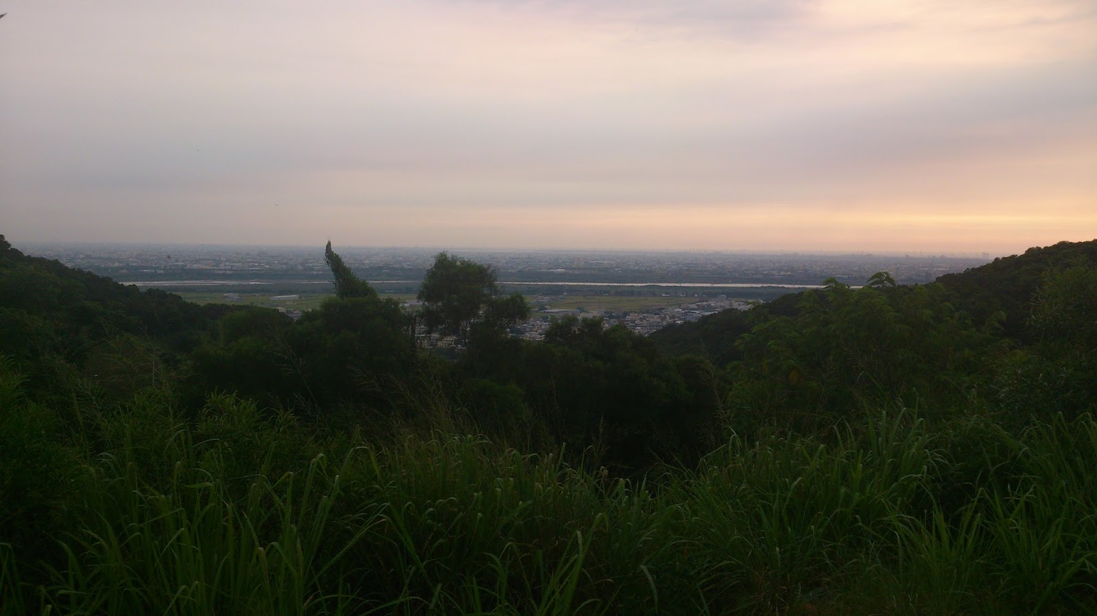
This picture was not a genuine success because of the gloomy weather. However, this is the top of the hill. From here, the road will make a little but steep descent and eventually connect to Taichung-90, the road of Gonglaoping.


I had only done a mere 35km from Shalu, but already more than 600 meters of elevation. For a shorter ride, those are good numbers.


This is the view you would get after completing Gonglaoping. I just got here via a little detour. The road that runs down here is Taichung-90 and leads to Shigang. I went down here today, because I wanted to connect to Tou'erping, another steep climb from Shigang to Xinshe.


So what I did was taking Taichung-90 all the way down, before connecting to Hwy 3 I went into a small lane on the right, which is where I took this picture. It is the starting point of Tou'erping. This is a continous climb of several kilometers that often has 16-17% gradients. One point even exceeds 20%.


If you just continue all the way along Tou'erping, you will make it to Taichung-93, one of the bigger roads that runs through Xinshe. This picture is the view on top of that road.


Orientating from Taichung-93, I went to Shuijing. Next phase of my mission would be to take Wanli Changcheng (Taichung-88) down. I saw this writing which says A-cheng. My Chinese name is Kuo Ruei-cheng and my friends call me A-Cheng sometimes. Even though it is a different character, I had to have this picture! 


Xinshe is renowned for the flowers they grow here. Every year in November there is a big flower exposition. As you can see, they are already making preparations for it.


And then the rollercoaster ride down Wanli Changcheng commenced... The next picture is a view of the hills along this road. Enchanting, isn't it?


Before going back to Fengyuan, I did one more thing. There is a small road at the T-section at the end of Taichung-88. I went to the right to check it out. I had heard people saying that that road would also lead to Xinshe. It was a lot of climbing and the road got smaller and smaller. In the end it did not lead anywhere. So I headed back to Fengyuan. However, looking at the Garmin map, it does appear to connect. This lane is described as "Shanshou Lane" and should connect to somewhere on Tou'erping. It is something I will have to investigate on a future ride.

Sunday, December 27, 2015

August 10, 2014: The story of my Central Taiwanese very first ride, the beginning of a wonderful chapter

Garmin Activity: https://connect.garmin.com/modern/activity/563227949
91km, 3h47, elevation 429m

This is a very special report for me, as it is my very first ride in central Taiwan. The only thing I regret about this ride is not taking more pictures. I did not have that traveling, photography mindset at the time. Luckily I did have my Garmin GPS with me so I am able to track the roads I cycled. I arrived in Taiwan on August 8th 2014 and the first two days were filled up with getting installed: a room to stay, a mobile phone number etc. On Sunday, the 10th of August, I had a day for myself and this would be my first cycling trip in Central Taiwan.

I set up my bike, which was looking nice with new carbon wheels and an S-Works frame. I had some top-notch gear! I did not know the central Taiwanese roads so I just relied on my GPS to calculate me a round trip of 160km. Of the three options given, I chose the one going south, which ran through Changhua and Yunlin county. I headed out dressed in yellow shoes, yellow helmet, yellow socks,  yellow jersey, completely in yellow.

The road led me to the Taichung Industrial Park. The first climb of the day was already very tough on me and I had to switch back to the lowest gear, which was a 30T cog. On top of that for me exhausting climb I went downhill. I missed a left turn so I had to go back a little. Then I was guided through the Taichung Industrial Park to Route 125. From there I went through Nantun and Wuri, eventually crossing the Dadu bridge. Hwy 1 took me into Changhua city.

In Changhua city, I saw the sign of Bagua mountain. I had read about Bagua mountain in a Taiwanese literature work. I was guided through some very small lanes and therefore average speed was not very high at all. I saw a mixe of roads, by looking on the map I know those roads where 148 and 144. Eventually I was on Hwy 19. I started raining when I was here. Great, rain on my first ride, that sucked! I was hiding under rooftop for some time to wait it out. When it did stop, I carried on. But there were more downpours...


All of the sudden it started raining very hard and intensively. I hid under this rooftop and stood here for quite some time. That was when I decided to aboard that whole ride I had planned. I calculated how for it would be to Xiluo, where there is a Specialized store. It was less than 30km , so that was my plan B


Again I was led by a mix of small roads, but I did remember route 145 which ran across over the beautiful red Xiluo Bridge. When I crossed that bridge, I was thinking what a narrow road. Please do not get a flat tire here! In Xiluo I asked people for directions on how to find the Specialized store. Eventually I found it and I met Duke Lu and his wife. We had a nice chat and I even saw the bike I ordered online. Also,  he explained to me how to go back home via train. Which was very nice of him. We had some food in a nearby store and when it was dark, I decided to go back home.


Garmin Activity: https://connect.garmin.com/modern/activity/563227907
23km, 58min, elevation 11m

I went to the Yuanlin train station via Hwy 1. There, I took a train that brought me back to Shalu. It was my first ride in Taiwan and I had various impressions. Obviously, there would be a lot more cycling ahead!

Saturday, December 26, 2015

June 21, 2015: The sudden discovery of Huanan road on a eye-caressing Sunday evening sunset

Garmin Activity: https://connect.garmin.com/modern/activity/810419514
58km, 2h24, elevation 560m

 It was ordinary Sunday afternoon and I had finished my classes at the language school at 5 pm. The next day I would be going to Hong Kong for visa purposes and therefore would be unable to cycle. That is why I wanted to do some cycling before going back to Shalu.

From Taichung city I went south via the Hwy 1-2. I ran through the districts of Nantun and Wuri. Wuri is named like that because of the river Wu that streams on the southern edge.


I first went through some heavier traffic and then I passed the Taichung High Speed Rail, which is on the above picture. One funny thing happened on my way here: There was red light but with the green arrow for going left. I did not see any cars coming from the other direction so I just rammed over that cross section. All of the sudden there is a cop shouting at me that I should stop. I ignored him and went on with my business. I have been looking back for several miles to see if I was followed. Luckily I wasn't. Nice escape from a probably heavy fine1


Bartman at Taichung HSR on a sunny Sunday afternoon!


I continued my ride, going past the Chenggong and Zhuifen stations. I had once taken the train from Shalu to Fengyuan and it passed these stations as well. Then I made it to Dadu township.


I wanted to do something different today and I saw this street, which I had seen a lot of times during previous rides. I never took the time to check it out, but I felt like it today. So I just went for it. When I saw this 12% sign I starting thinking: This might well be that famous Huanan road everybody is talking about... I met a somewhat thicker cyclist here and I asked him this question. He confirmed it to me. I was happy to learn that I was on Huanan road. I had heard people saying it was a tough ride and now I suddenly had the opportunity to judge myself. 


It did have that 12% gradient everybody talked about, but I was not suffering. Maybe I have really grown so much that this is easy as pie for me. I faced this climb with relative ease. The first section of Huanan road was one short climb and then the road turned flat again.


Riding a relaxing ride on Sunday afternoon at the Huanan road. I had a nice view over Taichung and the evening atmosphere was very enchanting.


The road was full of twists and turns and there was more elevation to be covered. I noticed that there were several MTB trails. I did read some blogs mentioning this. It offered some nice possibilities.


The view over Taichung city from Huanan road during a sunset. It looked a lot better in real life. I would even dare saying "breath taking"


A picture taken at the end of the second climb. I approximately covered 200 meters of elevation, relative to the starting point.


More views of Taichung city. I noticed there were more people riding here. It was clearly a destination loved by local cyclists


A picture of my bike almost at the top. Today was a special day for my bike, below you fill find out why...


This was a picture at the end of the climb. It says Huanan road in Chinese


A view back of this Huanan road. It is a nice climb with beautiful views, but honestly, it cannot match against Nantou rides. However, this was something nice for future rides...


Then I had to search a little on how to head back to Taiwan Boulevard. I was in the Longjing area now. I found the 136 and from there going back home was easy. This is a picture taken at the red light. I was taking a left here.


Right before arriving back home, I saw this fabulous 9000 km on my flatbar. I was over 90% for my 10,000 km I said I would do this year. Excellent stuff. Conclusion of the day: Huanan road is nice. I should consider doing it by default on night rides.


Friday, December 25, 2015

July 10, 2015: Shaking hands at Changhua's Birzman followed by a ride along the Han river to Fengyuan

Garmin Activity: https://connect.garmin.com/modern/activity/835577604
113km, 4h26, elevation 837m

I had a job interview at the Birzman company in Changhua today. I had already visited them once a few weeks ago and Lawrence, the company owner, invited me for a second talk. I agreed with him on today, as I would start a ride around Taiwan the next day.

Luckily I still remembered the road from the previous ride. However, there was a tiny little new aspect: From my place at Beishi Dong Road, I descended immediately and went left at the end of that descent. This road would eventually connect to 136 which would then again connect to Hwy 1 in Longjing. It got me on track for going south via Dadu and Wuri. I crossed the Dadu bridge and entered Changhua city, there I kept following Hwy 1 for some ten km more, until route 146 popped up. This section of the hwy is where all the big car dealers are located. I saw BMW and other brands here.

I took a right at 146 and crossed the railroad tracks. After a few km I made it to that 7-11 where I last time had some trouble finding the road. I took a moment to research the map a little.


The map of Dacun township, where the Birzman company was located


I saw that the road I was looking for was actually quite easy to find. I just had to continue following the road where the 7-11 was located and eventually I would be on that road. I would definitely recognize the company building.


My plan worked! I found the Birzman company with ease and I was on time for my interview. Rickie was already waiting for me.


Working here would also get me a company car, which would be a nice asset for cycling trips.


The job interview went well. It was more about what kind of person I was and what the company was looking for. It was a relaxed sphere. We concluded by officially shaking hands. I was on board and all that needed to be done was paperwork.  It felt good to have a new place to go to, after the trouble I ran into at the school. It would surely make my trip around the island a lot more fun, now that this was covered.

When I left the company, I decided to go to Fengyuan. I could still be there in the early afternoon with plenty of time for tea talks. My good buddy Liao Shi-jie had told me that I could go to Fengyuan by just connecting to the Han river. There was no need to take Hwy 3 which runs through every stopping sign in the city center. I wanted to check out this alternative...

The first section was the same, taking Hwy 1 north and connecting to Hwy 74, which runs over Bagua mountain and crosses routes 137 and 139, eventually leading back to Taichung city, going over the Wu river. There, I took Huanhe road (the road that runs around the river). Huanhe road led to Wufeng and eventually Hwy 3. This is exactly what I did last time.

What would be different was that I would not connect to Hwy 3, but I would continue cycling along this Han river, which also ran north. Honestly, this section still runs through Taichung city and there were a lot of red lights and bridges. It was a little better than Hwy 3 but not all that good. I was riding on the left bank of the river mainly until I had to go to the right edge because of road works. This is where I crossed the Songzhu road, a name that was well known by me.


After crossing Songzhu road I found myself on the right edge of the Han river. Skies were getting dark and it would be raining soon enough. Traffic was low over here and there was some cycling infrastructure.


Going to Fengyuan via the Han river.


I cycled through Tanzi and eventually on to Fengyuan. There were some signs that indicated a cycle around Taiwan bike path.


Going for Fengyuan on a bad weather day. I was spending two hours and 50km on the section from Changhua to Fengyuan.


Cycling trails along the Han river.


Riding on disc brakes with wider tires is so much fun. Will never go back again...


The Han river, today's lesson in geography. It is the river that runs all the way through Taichung city.


Eventually I made it to the Liancun community where Liao Shi-jie lives. It was nice to make it to Fengyuan from another perspective. I joined my friends for tea and talked about my job interview in Changhua. They were happy that a new chance had popped up for me. I also told them that I would be cycling around the island as of tomorrow and that I would keep in touch.

Thursday, December 24, 2015

June 11, 2015: A hundred degrees Fahrenheit at Dajia's Tiezhen mountain

Garmin Activity: https://connect.garmin.com/modern/activity/800692322
77km, 3h13, elevation 694m

Lately I am trying out new things on my bike. I am studying the Taichung area in-depth and I try to discover new sections on the map, sometimes by making a detour on my way to Fengyuan. That is also what I did today. 

I first climbed up to Metropolitan Garden via Houshanlu and from there I went to the Taichung airport. I rode Taichung-73 which runs behind the airport and then I took one of the smaller lanes that eventually led to Hwy 1. From there I crossed the Dajia bridge, going north.


The village on the southern bank of the Dajia river is called Haifengli, which in Chinese means Village of Sea Wind in Chinese. This place if filled with several tiny paths which are very cute. I found this temple very nice.


Haifengli, part of the Qingshui district in Western Taichung. This place looks like a place set back in time some 35 years.


Aohai road in Qingshui. There is a hill in Qingshui called the Aofeng mountain. That character is used in this street name. This is the street that leads from the sea (hai) to the aofeng hill (ao). From here the road passes through some fields before it connects to Hwy 1.


Dajia left, my direction for the day. Being out here was extremely nice, especially today on a good weather day.


Bartman all ready for new cycling explorations.


As I mentioned before, this section runs to several fields and is just the best alternative you can get to busy and crowded streets.  It is the western plains of Taiwan in their most genuine form.


Dajia, this way please. There is a longer descent here that crosses the highway bridge. By crossing I means it runs under it. There is no interaction with the cars of course.


Eventually you will make it to a small street callled Haiding road. Haiding road will connect to Hwy 1. From there I crossed the ever long Dajia bridge.


This part was along Hwy 1, with more traffic. This is where Dajia city center is. Just passed the city center, I entered route 132, which runs from west to east Taichung. I had my map with me and I knew how to get to the Tiezhen mountain Yuan Xin-yi was talking about. When I did not found it, I stopped at a 7-11 to ask for directions. It was very hot and I also bought a water-based popsstickle. The shop clerck told me that I had to follow Kaiyuan road. Luckily I found that one. Somehow I ended up on Taichung-27.


I was nearing the Tiezhenshan mountain


Beautiful green rice fields. It was a summer day indeed.


I did not find the entrance to the climb, but I did find some nice tourist information about this place


The Tiezhenshan park


Some historical notes about the Tienzhenshan hill,  its history runs back all the way to Qing China in the eighteenth century. There was some information about the two banks of the Dajia river. For those who understand Chinese, knock yourself out.


Only downside here was that I did not find the entrance to the climb up the hill. Too bad. I will do this another time. It was getting somewhat late and I decided to go further to Fengyuan.

 
A selfie at the Tiezhanshan hill.


As you can see, it was very hot.


Then I went somewhat south and east, going through the Waipu area. I was going in the direction of the Dajia river.


This area was also very tranquil, mostly rice fields and tiny roads.


I was just navigating based on street signs I saw. All I needed to do is finally go to Houli or Fengyuan. How I would get there was not important.


These rice plants have grown high, harvest would happen soon. Amazing view on a genuine summer day.


This moment called for a selfie


Not your average road bike trail.


More very local roads. I was heading for the Jiushe community,  which is in the northern bank of the Dajia river. It is part of Waipu but runs to Houli.


There was very steep hill here, it was more than 20 percent. I needed to use my largest cog for it.


Going for Houli through Jiushe


I love summer rides. I was completely forgetting that I was working today.


Green fields and clear blue skies. It was looking like a fairy tale


A nice view over this park


This spot connected to the northern bank of the Dajia river, from where I connected to Hwy 13, I went to Fengyuan like this. In the afternoon, I went to Taichung for my classes. It was a lovely short ride.


One peak moment of this ride: a hundred degrees Fahrenheit. That is somewhere around 40 degrees Celsius.