Garmin activity: https://connect.garmin.com/modern/activity/746210509
174km, 7h57, elevation 2778m
Yesterday I learned more about the 921 Earthquake. Last night I switched on my computer and did some research on that little road to Zhongliao which is not indicated on the map. I did not find much about it, just one blog in Chinese saying there is a little road called Nantou-26 which connects to a nameless mountain pass that eventually connects to 921 Mountain. But it would be a small and steep road which would be paved all way long. Sounds to me like a thrill!
The route I planned was going south from Shalu to Changhua, taking Route 139 south through Nantou city on to Zhongliao. According to the map, I would find the entrance to Nantou-26 on Route 139 and I would just have to keep following that one, eventually I would reach the sign I saw yesterday. So there I went, departing on my flatbar from Shalu, taking the usual Hwy 1 to Changhua city, through the red gate of Bagua Mountain on to 139.
Route 139, 20km mark, only a few km after entering through the big red gate in Changhua city center.
Good morning lads! Time to do some treasure hunting!
Most central Taiwan cyclists already know the ups and downs of 139, eventually you will make it to Nantou county.
My warm up was almost done! Only a mere 15km to Zhongliao, where today's focus would lay
After passing Nantou city en route to Zhongliao, I saw a lot of firemen at this building. Didn't see any smoke though. But from their facial expressions I could tell this was no ordinary exercise. I will never know what happened that day.
Yongle Road, the entrance to Nantou-26. The fact I was able to find this one was thanks to my understanding of how the Taiwanese road infrastructure has a lack of consistence. At first I would always remember the number of a road, e.g. Hwy 1, Route 136, Taichung-99 etc. But in real life that will help you nowhere, since not a Taiwanese memorizes them and you can not always find them indicated on the signs. Sometimes they're there, sometimes they're not. So I did a combo of the two: memorizing the number (in this case Nantou-26) ánd the street name (Yongle road). That is the only reliable way of being able to find or ask directions outdoors. Fellow cyclists, please bear this in mind.
I took a quick bite at this spot and studied the map. I knew exactly how to go.
The entrance of Nantou-26
It was not noon yet, but it was already sizzling hot! Tropical Island of Formosa
There we go, Nantou-26, 3km mark! This section was only about 8km and then we would face the remoteness of the Zhongliao mountain range
The weather was really good in the sense that I would not want to climb that mountain in a downpour
A split section, I was going left. I will have to check out that other direction another time.
Making progress along Nantou-26
Bingo! I saw the Chinese name of 921 Mountain indicated a first time. A confirmation that I wasn't dreaming, but doing research based on reasonable assumptions! I loved that feeling!
A little parc. Must be some residents nearby. Very tranquil and isolated
I like these pinkish stones on the ground. However, I was not going inside, I was going to pursue my journey along Nantou-26
Exactly, in that direction
No words to describe the beauty of this view. It looked a lot better in real life
Boom! Here it is! The end of Nantou-26 and therefore, the end of today's road map indicated route. From here it would be little farm roads until I make it to that sign from yesterday. God, stay with me on this one!
Little paths between a multitude of betel nut trees. Good thing I'm not addicted, or I'd never make it to the top.
No road signs on this section, but that red writing in Chinese on the wall was just super convenient. It is Chinese for 021 Mountain to the right. Occasionally I would come across these indications that I was going the right way. It prevented me from feeling lost.
The road was ascending with a constant 8%. Nothing that will kill you, just a nice constant gradient. But is was getting hotter and hotter and I must say I was counting every kilometer I completed after leaving Nantou-26.
The roads were not terrific, but acceptable! I was riding with a 25mm tire on the front, and a 28mm tire on the back. It did give me the necessary flat protection. Wouldn't wanna face a flat tire on a no man's land like this!
Honestly speaking, this is a fantastic ride! I was smiling most of the time just thinking about how crazy I am for doing this.
Another red road indication, fan-tas-tic! xD
Exceptional view, really shows you that other side of Taiwan. Too bad not even the Taiwanese themselves take the time to check it out
Like I said before, I thanked my lucky stars it was not raining. It had been dry for almost two weeks so this section was very doable. But I did encounter a few small mud piles and water. Nothing serious, but remember I am riding a road bike here, no MTB haha
The skyline of the Zhongliao mountain range. Nothing like Hong Kong or London, but its beauty did not go by unnoticed
Bartman at 800m elevation, still going up
gravel roads
Another indication I was going the right way
As you can see, still a few hundred meters to go 'till I reach the top.
At this point I had already completed 10km of cycling after Nantou-26 ended. 10km would have to imply that I was almost there. Keep on cycling!
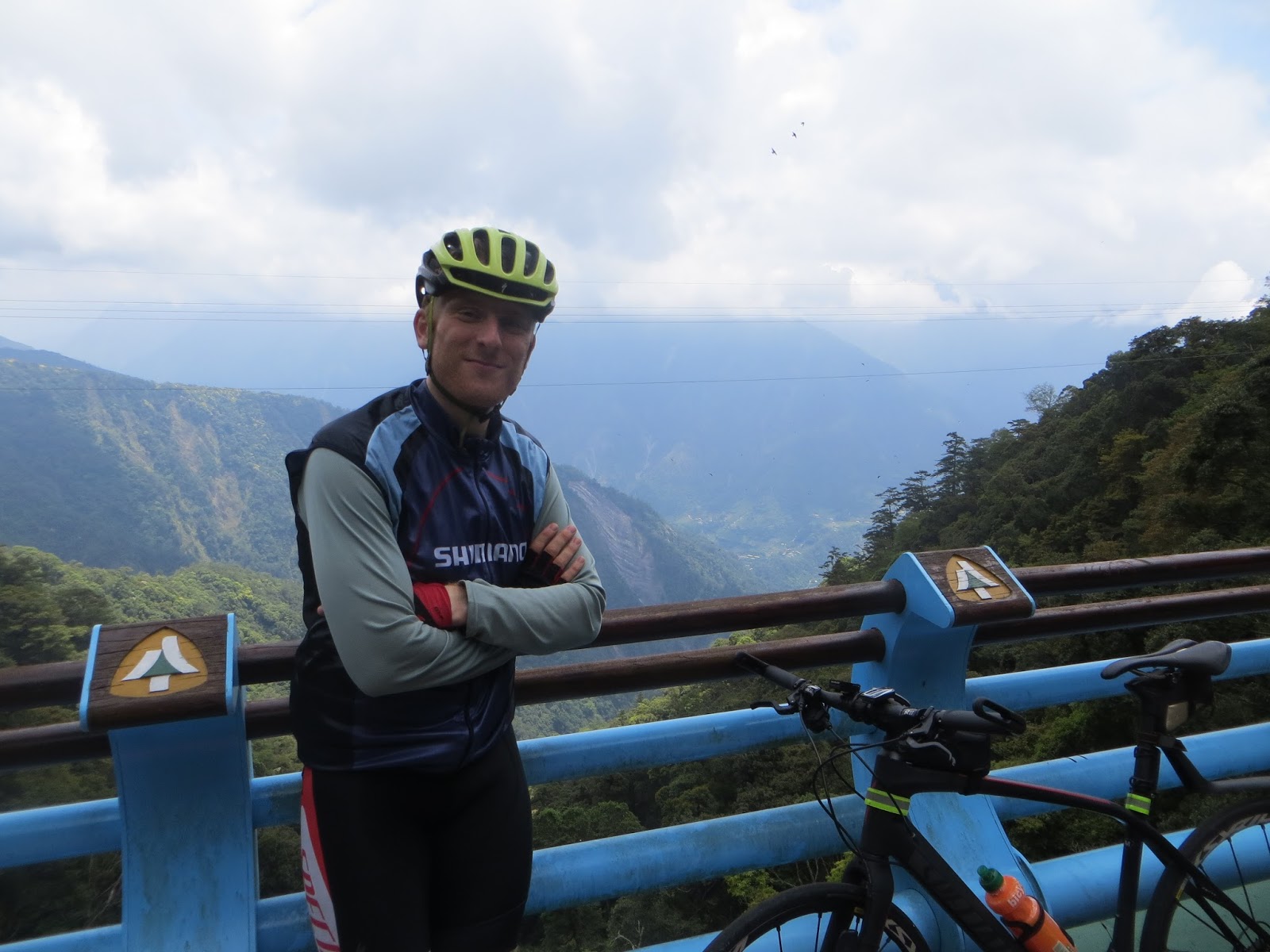
When I was almost there, I saw a guy in a military outfit walking down here. I tried to tell him that it was more than 10km down and that it would take him at least two hours. He told me he often did it and that he was ok with it. I did not see him carry any water. Crazy guy! But he did take this awesome picture of me, for which I am grateful!
I saw a little truck down the road, they must have been collecting betel nuts. These signs of activity indicated that I was close to the end.
Another sign to 921
Oh my God! I am here! I made it! I was so happy when I saw this spot. Not that I was having a hard time. It was only like 12-13km uphill and there were signs, but it was still a very special experience! Glad I did it!
What a bright sunny day, unbelievable! From here, I was descending the 921 mountain to Route 147
I had my lunch on this spot. It was a little past one. The time was perfect and I had survived the hardest part of the day. Now all I had to do was go back to Taichung, Fengyuan and have some tea. I entered Guoxing township and restocked my backpack and continued my journey. As I had already done Hwy 21 and Baimaoshan yesterday, I wanted to take a different route today. I chose the very steep and remote Changliupo (Nantou-97) to Xinshe. Another steep 12km ascent to 1100m of elevation.
I had done this section 3-4 times, once in heavy weather. Today was going to be relaxing. All I did was small mountain paths between mountain ranges. What a creative ride!
Very steep at some points, one specific spot even goes as steep as 22%. Got me sweating bad
Such a cute little road between the betel nut trees. Not a vehicle around, just me and the surroundings. This is exactly the Taiwan I like.
I just came from this direction. The little blue sign indicates Guoxing area.
A hidden paradise within central Taiwan
The peak of this mountain
April has been a month without a proper road bike, but this buddy is easing the pain big time
The traditional picture, coming down from the left, pursuing my way left
Xinshe area, Taichung-95. I went to Fengyuan for tea and concluded this wonderful quest with a smile. I had absolutely wonderful conditions for this ride