Garmin Activity: https://connect.garmin.com/modern/activity/647479688
245km, 10h00, 3000 elevation
Today's trip would be more adventuring than pursuing numbers. Obviously this 245km, 10h and 3000m ride is still packed with some incredible numbers but the main goal of today's journey was to experience this remote area that very few people, including the Taiwanese themselves, visit. Most people will take Hwy 14 up to Qingjing farm and go to Wuling or even Hualien. Very few people would spend a day at Lushan. I had already visited the above mentioned areas, so now I wanted to check out this Lushan which I had been seeing on road signs for months.
As usual I set out from Shalu, went to Taichung city on to the Wufeng area (South of Taichung). From there my GPS led the way through some small roads to Caotun. Caotun is the main hub for Hwy 14. From there on it was pretty easy: just keep following this Hwy 14 until it stops. Caotun is located at the 20km mark of this road, the end mark would be 99km, times two would make for a nice all day ride.

Doing my homework working with maps, combining good old printed maps with modern GPS technologie

A closer look into today's mission, Lushan and Tunyuan

Located at the very extreme of Hwy 14. According to a blog I read, the 99km mark of this Hwy 14

Early morning in Caotun. This time I led my GPS lead the way, which sent me through a few adorable small field roads

De morgenstond heeft goud in de mond, a famous Dutch proverb, praising the beauty of sunrise

Good morning selfie! We got a long day ahead!

Up to here is a section which I had already cycled a handful of times. I always went from Taichung to Wufeng, Caotun and Guoxing on to Puli. Continuing Hwy 14 from Puli leads through Renzhiguan (75km mark with some climbing involved). That section will lead to a village called Wushe, in Ren'ai county. There is a 7-11 and a Family Mart in Wushe which will give you the possibility to restock on essential needs. Then you get to see the above sign: left is Hwy14-2 which goes up to Hehuan Mountain at 3275 meters and is definitely the road most traveled of these two. I had already ridden it twice before, both in November. Straight ahead or to the right if you prefer, is the road to Lushan, today's goal. At this point I could say nothing about it as I had never done it before.


This section was obviously a lot less traveled than the section to Wuling. It still presented a few climbs but nothing compared to the big one that was just on my left. Nearing the 84km mark I knew I was only 15km away from today's goal. The views were really spectacular. It felt great just being at such a far away location, not a cyclist around, just me and this enticing environment.

Highway 14, 84km mark

The only red bridge I would come across in this section. I noticed quite a few vendors selling fruits on the side of the road. Some local friends told me that often they sell them as exclusive fruits, grown in some expensive area but then they turn out to be of far less quality. Wasn't gonna carry a crate of heavy fruits anyway :-)

I really like those red bridges everywhere, and there is even a mini tunnel in the end

A platform for tourists who can have their pictures taken here

So obviously I needed to get one too

Lushan hot spring, this is a famous Hot Spring center and I did see some tour buses waiting here.

But my journey would continue up that hill behind me, which would be more of Hwy 14. After this intersection the road's conditions did not improve, on the contrary, and I started noticing an average gradient of about 7%. Still some climbing ahead though!


Just a few snapshots that display the joyful wonders of exploring remote areas

Aboriginal statue. There is a 7-11 in Puli where I always stop for food and drinks and I know the shop owner. He is an aboriginal, part of the Saideke tribe. He told me that the area of Lushan was part of the Saideke tribe. He added that only in recent years the government had acknowledged the Saideku to be an independent tribe. Before that, they had always been sub-categorized as part of the Ataya group. The difference is of course identity and legal benefits from the status as an aboriginal. Nice to know these things, after all, the island of Formosa is their property and the Han race is not native to these area's. So rather than talking about cross-strait fora, it would be better to understand the true nature of this beautiful island. Exactly my mission for today!


At this section there were two options, one going right and following Hwy 14 (it was still about 7-8km from here) and the other taking this little industry road to the Hezuo tribe. Today I went for Hwy 14 but I will come back for this Hezuo tribe. Later I learned from checking my maps that this Nantou85 road would lead all the way to Cuifeng on Hwy 14-2. I know from local cyclists that this is a very steep and challenging section. Just don't have time for it today... One day I will!


Tunyuan lies ahead of me, which is the last of place names I will encounter here. I will talk about the Nenggao West Line later on

A summary of the traffic situation of my current position. Tunyuan is where I am heading

Hwy 14, 94km mark, 5km to go!

But all of them were climbing! This area actually really looked like the road to Wuling, just little mountain path that kept gaining altitude. I went past a check point where people were staring at me. For a moment I felt strange, as if I was approaching imminent danger...

But that fear was suddenly overcome by a feeling of joy, joy for just doing this trip

A mountain path wouldn't be the same without falling rocks. Just make sure them road bike tires don't get a flat over 'em rocks :-)

And of course, road construction works. I could pass without too much difficulty. Moreover, riding these 700x30c tyres made me feel a lot more at ease, as if nothing could possibly hurt me.

More views, more loneliness

Well then, this is it! The end of Hwy 14, at 99km. I remember this image from a blog I had been reading about it. Now back to the Nenggao Westline I mentioned earlier. That is a mountain path that leads all the way to Hualien county. This is exactly where it commences. That section is road bike impossible. I saw some blogs about people riding through here with MTB's. Later I heard people from a bike shop telling me that due to Typhoons that section has become impossible to pass, with the road between the mountain edges being dangerously and ridiculously small. None of them said I should try. Maybe I really shouldn't, since the distance from here to Hualien is still a crazy 100km. And I would not want to spend the night on this creepy mountain. Although the thought of making it to Hualien from here really does sound exciting...

Anyway, today's mission accomplished. I made it to 99km on this road, still feels great. One I can cross off the to do list

From here the road seems doable, but for this one I will take the Taiwanese for their word

Feeling hungry, time to head back

A view from the other side. Going back to 20km brings me very close to Taichung and Shalu
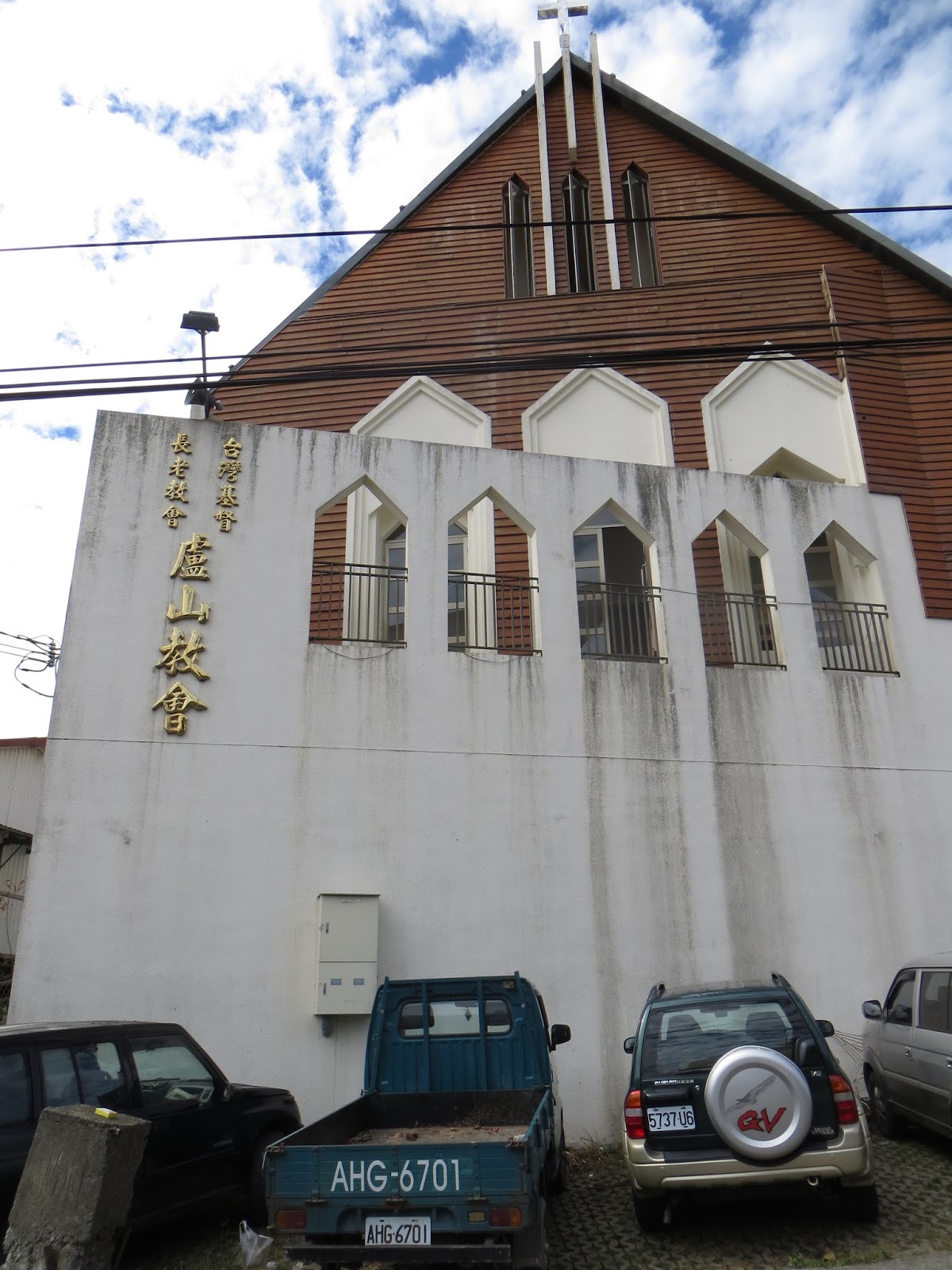
A Christian church in the middle of this far located aboriginal village, now that is really cool! Definitely a remainder of Dutch and other European's time on Taiwan several hundreds of years ago. There was a little shop somewhere around here where I bought some snacks. The people where really enthusiastic seeing a white guy here. I chatted with them for 15 minutes. There was even an Indonesian girl working there who was fairly cute. I found it strange to see a non-aboriginal person working and living there. But I am sure she loved her life there, devoid of stress.

I went back in the opposite direction, going from Tunyuan to Lushan back to Wushe. From there I went back to Puli. I did not want to repeat the entire Hwy 14 thing to Caotun so I went the other way, taking Hwy 21 in Puli, which leads to Dongshi in eastern Taichung. From there I went to Fengyuan for some tea and then back home. Basically the traditional route back home. It helped me avoid repeating the same road twice and it helped me accumulate a beautiful 245km. The above picture is between Puli and Guoxing, the 40km mark of Hwy 21. When this thing counts down to zero, I am back in Taichung.


The 30km mark of Hwy 21, this is in Guoxing, right before Baimaoshan. It is the halfway point between Puli and Dongshi. I just really love this background setting, even had it for a computer desktop background for some time.


Guoxing township in Nantou, about the 23km mark of Hwy 21


The last section of the day was the climb from Guoxing to Dongshi. What a nice day I had! Hope to be repeating this one soon!
No comments:
Post a Comment