Garmin Activity: https://connect.garmin.com/modern/activity/672622166
188km, 7h14, elevation 1074m
This would be a nice relaxing ride today. I set out from Shalu, going south via the coastal highway 17. I had done this section a few times before and if the wind was blowing in the right direction, this would really be a fun ride.
A picture from a Longjing village along Hwy 17, early in the morning. It was a bit chilly, with a gentle breeze.
I continued my way South, passing the Zhongzhang bridge (between Taichung and Changhua). In Changhua county, I passed through the townships of Shengang, Xianxi and Lugang. I had learned about Lugang in a history book on Taiwan. As its Chinese name points out, Lugang is the "deer habror", the harbor where deers were traded with Chinese traders. This deer catching and trading rage went completely out of hand and led to the eventual extinction of the deer species in Taiwan. One of the less glorious remainders of European presence in Taiwan. But on the other hand, without Chinese clientele, those deers would not have been noticed in the first place.
Anyway, I made it to Lugang city center really fast. There were many ancient temples in this historic area of Lugang. What did upset me was the outright ridiculous reaction I got from several people when I took these pictures. I rarely get these kind of reactions, but that was just pure racism. Maybe they were mainlanders. I told them to go F themselves and refused to have my mood affected by it. I did leave Lugang right away and continued my journey south.
Lugang streets
A few people were really impolite and rude just because I put my bike there. Also mind the scooters that are everywhere in the scene. Racism in its finest form :-)
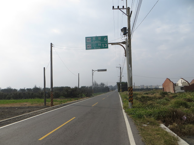
Then I found myself in the south of Changhua county. I had crossed the Yunlin bridge to Mailiao several times, so this time I wanted to do something different. Somewhere btween Fuxing and Fangliao township, I switched to Route 143, which led to the south of Changhua, but without crossing the Zhuoshui river.
Erlin was where I was going, in 13km that is. This section was 100% flat, just some nice views along the way to pass the time.
Yeah, I was wearing a jacket. I noticed that January in Taiwan still has its chilly edge.
I saw a little offroad path on my right, there aren't that many in Taiwan to be honest. I went in and took some nice photos. That 28mm armadillo elite tire still gave me a fantastic feeling on this ground.
Rice fields in central Taiwan, very enchanting
Parking my dearest under the trees
Riding an MTB today would be nice, I could go check out what lies beyond.
After thirteen kilometers of Route 143, I ended up at an intersection. It required me a few minutes of map studying before I understood what I was supposed to do. Dacheng would be going further south, Fangliao was my current location. So the only thing left to do was going east to Zhutang via Route 150.
I followed this Route 150 all the way east, passed through some small townships, such as Beidou and Tianzhong. After passing Tianzhong, I saw where I was. I had cycled this section of Route 150 once in 2014, when I was cycling Route 137 all the way down and then connected to 150. I remember there was a 4.5km climb, with the first section being about 10%, passing by a vocational high school. This section is where I collected almost the entire elevation for the day.
After that nice climb there was also a somewhat longer descent and I found myself in Nantou County's Mingjian township.
Mingjian also had some amazing views to offer a foreigner like myself. Another nice discovery.
Route 150 eventually led to Nantou city, where I connected to Hwy 3. I kept following Hwy 3 north, going through Caotun and Wufeng until Taichung city.
In Taichung I connected to Route 129, going from Dali all the way up to Xinshe. I did that climb until Zhongxingling. I would also have this climb in the race of Saturday (Dasanyuan).


No comments:
Post a Comment